Geolocate

thapla topographic map

Click on the map to display elevation.

About this map

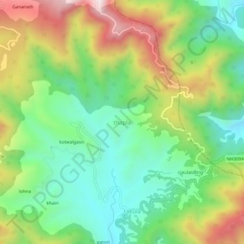
Name: thapla topographic map, elevation, terrain.

Location: thapla, Almora, Uttarakhand, India (29.72663 79.67754 29.76663 79.71754)

Average elevation: 1,642 m

Minimum elevation: 1,381 m

Maximum elevation: 2,064 m

Gear up for your next adventure:

🪜Heavy Duty Carabiners - Multi-use clips for securing gear to your backpack
🩹Moleskin Blister Pads - Direct protection for painful foot pressure points
🥾Hiking Shoes - Durable and comfortable shoes for trail hiking
🛌Down Sleeping Bag - Superior warmth-to-weight ratio for cold nights
🧥Softshell Jacket - Windproof and breathable jacket for hiking

As an Amazon Associate, this site earns from qualifying purchases at no extra cost to you.