
Make a donation
Gear up for your next adventure:
As an Amazon Associate, this site earns from qualifying purchases at no extra cost to you.
Villa Carlos Paz topographic map
Click on the map to display elevation.
Make a donation
Gear up for your next adventure:
As an Amazon Associate, this site earns from qualifying purchases at no extra cost to you.
Villa Carlos Paz
La ciudad ocupa una superficie de 2680 hectáreas. Su altitud es de unos 666 metros sobre el nivel del mar. Geográficamente se ubica entre los 35°25′ de latitud sur y los 64°31′ de longitud oeste. Políticamente pertenece a la pedanía San Roque (Córdoba) del Departamento Punilla, provincia de Córdoba.
Make a donation
Gear up for your next adventure:
As an Amazon Associate, this site earns from qualifying purchases at no extra cost to you.
About this map
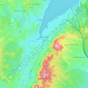
Name: Villa Carlos Paz topographic map, elevation, terrain.
Average elevation: 717 m
Minimum elevation: 634 m
Maximum elevation: 955 m
Make a donation
Gear up for your next adventure:
As an Amazon Associate, this site earns from qualifying purchases at no extra cost to you.
Other topographic maps
Click on a map to view its topography, its elevation and its terrain.