
Make a donation
Gear up for your next adventure:
As an Amazon Associate, this site earns from qualifying purchases at no extra cost to you.
Col d'Èze topographic map
Click on the map to display elevation.
Make a donation
Gear up for your next adventure:
As an Amazon Associate, this site earns from qualifying purchases at no extra cost to you.
About this map
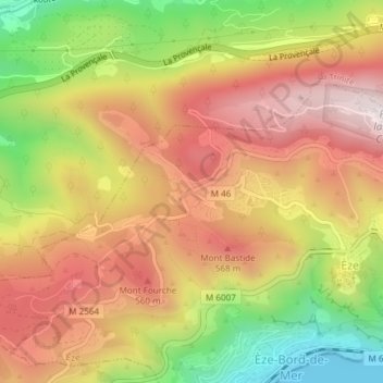
Name: Col d'Èze topographic map, elevation, terrain.
Average elevation: 389 m
Minimum elevation: 0 m
Maximum elevation: 699 m
Make a donation
Gear up for your next adventure:
As an Amazon Associate, this site earns from qualifying purchases at no extra cost to you.
Other topographic maps
Click on a map to view its topography, its elevation and its terrain.
Fort de la Revère
France > Provence-Alpes-Côte d'Azur > Alpes-Maritimes > Èze
Le fort de la Revère, appelé brièvement fort Anselme, est un ouvrage militaire construit entre 1882 et 1885 au-dessus du village d'Èze dans le Parc forestier de la Grande Corniche du département des Alpes-Maritimes en France. Situé à 696 m d'altitude, il domine sur une ligne de crête toute la côte…
Average elevation: 420 m