
Make a donation
Gear up for your next adventure:
As an Amazon Associate, this site earns from qualifying purchases at no extra cost to you.
Magliolo topographic map
Click on the map to display elevation.
Make a donation
Gear up for your next adventure:
As an Amazon Associate, this site earns from qualifying purchases at no extra cost to you.
Magliolo
Magliolo liegt im Valle Maremola am gleichnamigen Fluss. Das Gemeindegebiet reicht von 100 bis 1335 Meter über dem Meeresniveau. Die Verwaltungsgebäude liegen auf einer Höhe von 270 Metern.
Make a donation
Gear up for your next adventure:
As an Amazon Associate, this site earns from qualifying purchases at no extra cost to you.
About this map
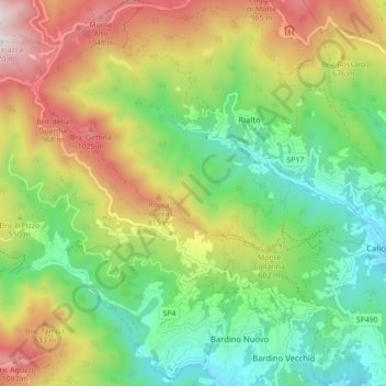
Name: Magliolo topographic map, elevation, terrain.
Location: Magliolo, Savona, Ligurien, Italien (44.18364 8.17188 44.24406 8.25948)
Average elevation: 505 m
Minimum elevation: 59 m
Maximum elevation: 1,207 m
Make a donation
Gear up for your next adventure:
As an Amazon Associate, this site earns from qualifying purchases at no extra cost to you.