Geolocate

Sarandi topographic map

Click on the map to display elevation.

Sarandi

Localiza-se a uma latitude 23º26'37" sul e a uma longitude 51º52'26" oeste, estando a uma altitude de 592 metros.

About this map

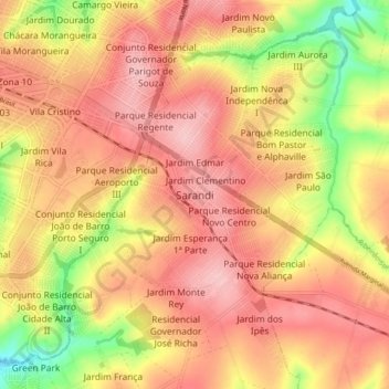
Name: Sarandi topographic map, elevation, terrain.

Location: Sarandi, Região Geográfica Imediata de Maringá, Região Geográfica Intermediária de Maringá, Paraná, 87113-010, Brasil (-23.48412 -51.91602 -23.40412 -51.83602)

Average elevation: 540 m

Minimum elevation: 447 m

Maximum elevation: 595 m

Gear up for your next adventure:

🥾Mountaineering Boots - Supportive boots for climbing and high-altitude hiking
🔥Emergency Fire Starter - Reliable ignition source for all weather conditions
Camping Coffee Maker - Brew fresh coffee anywhere on the topographic map
🦶Anti-Blister Balm - Prevents friction and hotspots during long ascents
🥾Waterproof Trail Shoes - Shoes designed to handle wet terrain

As an Amazon Associate, this site earns from qualifying purchases at no extra cost to you.