
Bengkulu topographic map
Click on the map to display elevation.
Bengkulu
The region is at low elevation and can have swamps. In the mid-19th century, malaria and related diseases were common. Bengkulu lies near the Sunda Fault and is prone to earthquakes and tsunamis. The June 2000 Enggano earthquake killed at least 100 people. A recent report predicts that Bengkulu is "at risk of inundation over the next few decades from undersea earthquakes predicted along the coast of Sumatra" A series of earthquakes struck Bengkulu in September 2007, killing 13 people. Bengkulu City has an area of 151.70 km ² and is located on the west coast of Sumatra island, with the province having a coastline of about 525 km in length. The area of this city lies parallel to the mountains of Bukit Barisan and face to face with the Indian Ocean.
About this map
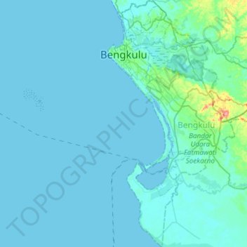
Name: Bengkulu topographic map, elevation, terrain.
Location: Bengkulu, Teluk Segara, Bengkulu, Sumatra, Indonesia (-3.98167 102.17916 -3.73952 102.37154)
Average elevation: 6 m
Minimum elevation: -2 m
Maximum elevation: 90 m