
Thornham topographic map
Click on the map to display elevation.
About this map
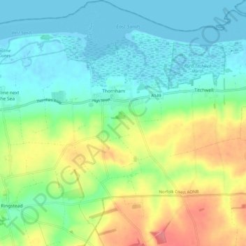
Name: Thornham topographic map, elevation, terrain.
Average elevation: 24 m
Minimum elevation: -2 m
Maximum elevation: 73 m
Other topographic maps
Click on a map to view its topography, its elevation and its terrain.
Burn
United Kingdom > England > Norfolk > King's Lynn and West Norfolk > Burnham Overy
Average elevation: 16 m
Brancaster Staithe
United Kingdom > England > Norfolk > King's Lynn and West Norfolk
Average elevation: 18 m