Geolocate

Galeton topographic map

Click on the map to display elevation.

About this map

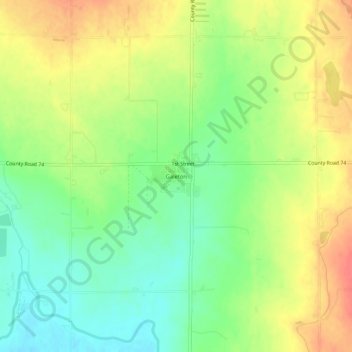
Name: Galeton topographic map, elevation, terrain.

Location: Galeton, Weld County, Colorado, 80622, United States (40.50081 -104.60579 40.54081 -104.56579)

Average elevation: 1,460 m

Minimum elevation: 1,433 m

Maximum elevation: 1,488 m

Gear up for your next adventure:

🔦LED Headtorch - Bright and durable light for night activities
🧭Orienteering Kit - Tools for map reading and navigation in the wild
🗺️Topographic Maps - Detailed maps to explore trails, mountains, and wilderness areas
Camping Essentials - All-in-one gear for a comfortable camping trip
🥾Mountain Hiking Boots - High-traction boots for rocky terrain

As an Amazon Associate, this site earns from qualifying purchases at no extra cost to you.