Geolocate

Bambuí topographic map

Click on the map to display elevation.

Bambuí

The city center of Bambuí is located at an elevation of 706 meters on a plateau and straddles the 20th parallel. Neighboring municipalities are: Tapiraí and Córrego Danta (N), Luz (NE), Iguatama (E), Doresópolis (SE), Piumhi (S), São Roque de Minas and Medeiros (W).

About this map

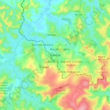
Name: Bambuí topographic map, elevation, terrain.

Location: Bambuí, Região Geográfica Imediata de Formiga, Região Geográfica Intermediária de Divinópolis, Minas Gerais, Southeast Region, 38900000, Brazil (-20.05320 -46.01770 -19.97320 -45.93770)

Average elevation: 708 m

Minimum elevation: 661 m

Maximum elevation: 796 m

Gear up for your next adventure:

💡Portable Camping Lamp - Rechargeable lamp for campsite lighting
🧴Outdoor Sunscreen - High SPF protection for high-altitude UV exposure
🥾Mountain Trail Shoes - High-traction shoes for mountain trails
🔭Compact Monocular - One-handed bird watching and trail spotting
🔦UV Flashlight - Detect minerals or specific insects in the dark

As an Amazon Associate, this site earns from qualifying purchases at no extra cost to you.