Geolocate

Goreme topographic map

Click on the map to display elevation.

About this map

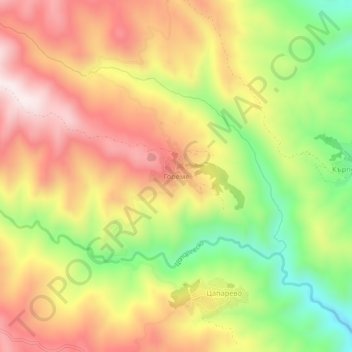
Name: Goreme topographic map, elevation, terrain.

Location: Goreme, Strumiani, Blagoevgrad, 2834, Bulgaria (41.62051 23.07193 41.66051 23.11193)

Average elevation: 740 m

Minimum elevation: 431 m

Maximum elevation: 1,009 m

Other topographic maps

Click on a map to view its topography, its elevation and its terrain.

Рупите

Bulgaria > Blagoevgrad

Average elevation: 117 m

Тевно езеро

Bulgaria > Blagoevgrad

Average elevation: 2,429 m

Frog lake

Bulgaria > Blagoevgrad

Average elevation: 2,410 m

Gear up for your next adventure:

🧥Packable Rain Jacket - Breathable waterproof layer for unpredictable weather
🔥Emergency Fire Starter - Reliable ignition source for all weather conditions
🪑Ultralight Camping Stool - Compact seating for rest stops during long hikes
Family Camping Tent - Spacious tent suitable for family camping trips
💧Reusable Water Bottle - Durable water bottles for hydration on trails

As an Amazon Associate, this site earns from qualifying purchases at no extra cost to you.