
Make a donation
Gear up for your next adventure:
As an Amazon Associate, this site earns from qualifying purchases at no extra cost to you.
Donnern topographic map
Click on the map to display elevation.
Make a donation
Gear up for your next adventure:
As an Amazon Associate, this site earns from qualifying purchases at no extra cost to you.
About this map
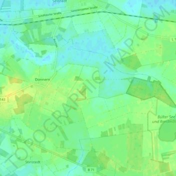
Name: Donnern topographic map, elevation, terrain.
Average elevation: 8 m
Minimum elevation: -1 m
Maximum elevation: 20 m
Make a donation
Gear up for your next adventure:
As an Amazon Associate, this site earns from qualifying purchases at no extra cost to you.
Other topographic maps
Click on a map to view its topography, its elevation and its terrain.
Hosermühlen
Deutschland > Niedersachsen > Landkreis Cuxhaven > Loxstedt > Bexhövede
Average elevation: 5 m
Make a donation
Gear up for your next adventure:
As an Amazon Associate, this site earns from qualifying purchases at no extra cost to you.
Dedesdorf-Eidewarden
Deutschland > Niedersachsen > Landkreis Cuxhaven > Loxstedt
Average elevation: 0 m