
Timaná topographic map
Click on the map to display elevation.
Timaná
Timaná is a town and municipality in the Huila Department, Colombia. The municipality is located in the south of Huila at an altitude of 1,100 metres (3,600 ft) and 166 kilometres (103 mi) southwest of the capital Neiva.
About this map
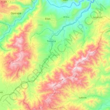
Name: Timaná topographic map, elevation, terrain.
Location: Timaná, Sur, Huila, RAP (Especial) Central, Colombia (1.85355 -76.00253 2.04620 -75.82557)
Average elevation: 1,388 m
Minimum elevation: 831 m
Maximum elevation: 2,151 m
Other topographic maps
Click on a map to view its topography, its elevation and its terrain.