
Make a donation
Gear up for your next adventure:
As an Amazon Associate, this site earns from qualifying purchases at no extra cost to you.
Como topographic map
Click on the map to display elevation.
Make a donation
Gear up for your next adventure:
As an Amazon Associate, this site earns from qualifying purchases at no extra cost to you.
Como
Como liegt am Fuß der italienischen Voralpen, am Südwestende des Comer Sees, der sich auf der Höhe von Menaggio nach Süden in zwei Arme (Lago di Como und Lago di Lecco) teilt. Weil der Abfluss des Comer Sees, die Adda, den See bei Lecco verlässt und der andere Arm des Sees keinen Abfluss hat, wird zu Zeiten der Schneeschmelze und besonders starker Niederschläge, ganz besonders bei Nordwind, der das Wasser gegen Como staut, die Stadt fast jährlich von Hochwasser heimgesucht. Die Stadt liegt verkehrsgünstig an der Eisenbahnlinie Mailand-Zürich und an der Autostrada A9, die sich in der Schweiz als A2 („Gotthard-Autobahn“) fortsetzt, was zur Ansiedlung vieler Industriebetriebe geführt hat.
Make a donation
Gear up for your next adventure:
As an Amazon Associate, this site earns from qualifying purchases at no extra cost to you.
About this map
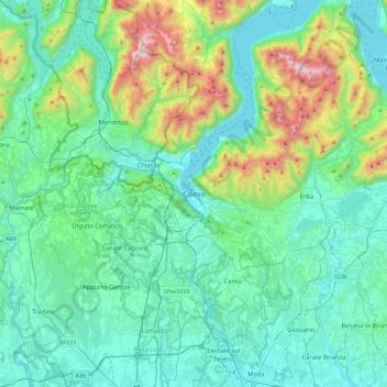
Name: Como topographic map, elevation, terrain.
Location: Como, Lombardei, 22100, Italien (45.65156 8.92304 45.97156 9.24304)
Average elevation: 465 m
Minimum elevation: 188 m
Maximum elevation: 1,667 m
Make a donation
Gear up for your next adventure:
As an Amazon Associate, this site earns from qualifying purchases at no extra cost to you.