
Thank you for supporting this site ❤️
Make a donation
Make a donation
Gear up for your next adventure:
As an Amazon Associate, this site earns from qualifying purchases at no extra cost to you.
Sequeiras topographic map
Click on the map to display elevation.
Thank you for supporting this site ❤️
Make a donation
Make a donation
Gear up for your next adventure:
As an Amazon Associate, this site earns from qualifying purchases at no extra cost to you.
About this map
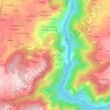
Name: Sequeiras topographic map, elevation, terrain.
Location: Sequeiras, Camporramiro, Chantada, Galicien, 27514, Spanien (42.56388 -7.75053 42.60388 -7.71053)
Average elevation: 452 m
Minimum elevation: 200 m
Maximum elevation: 632 m
Thank you for supporting this site ❤️
Make a donation
Make a donation
Gear up for your next adventure:
As an Amazon Associate, this site earns from qualifying purchases at no extra cost to you.