Geolocate

Bansko topographic map

Click on the map to display elevation.

Bansko

Bansko lies at the foot of the Pirin Mountains, not far from the national park of the same name, in the valley of the Nestos River at an elevation of 925 meters above sea level. It is a ski resort. The city is about 160 km from Sofia and about 220 km from Thessaloniki.

Wikipedia (CC-BY-SA 3.0)

About this map

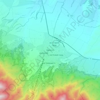
Name: Bansko topographic map, elevation, terrain.

Location: Bansko, Blagoevgrad, 2770, Bulgaria (41.79441 23.44417 41.87441 23.52417)

Average elevation: 1,034 m

Minimum elevation: 801 m

Maximum elevation: 1,918 m

Other topographic maps

Click on a map to view its topography, its elevation and its terrain.

Рупите

Bulgaria > Blagoevgrad

Average elevation: 117 m

Тевно езеро

Bulgaria > Blagoevgrad

Average elevation: 2,429 m

Frog lake

Bulgaria > Blagoevgrad

Average elevation: 2,410 m

Gear up for your next adventure:

🌬️Windproof Camp Stove - Efficient cooking even on exposed mountain peaks
🥤Collapsible Travel Cup - Saves space and weight in your mess kit
🥾Hiking Shorts - Breathable shorts suitable for summer hikes
💧Collapsible Water Bottle - Space-saving water bottle for outdoor activities
🛌Insulated Sleeping Pad - Critical thermal barrier between you and the cold ground

As an Amazon Associate, this site earns from qualifying purchases at no extra cost to you.