Geolocate

Reinickendorf topographic map

Click on the map to display elevation.

About this map

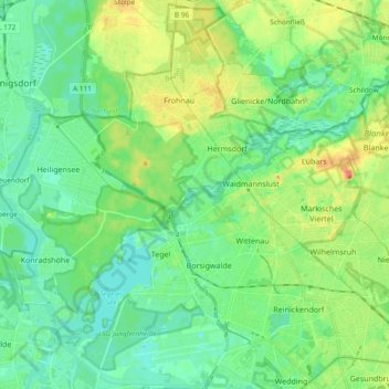
Name: Reinickendorf topographic map, elevation, terrain.

Location: Reinickendorf, Berlin, Germany (52.54881 13.20162 52.66074 13.38928)

Average elevation: 42 m

Minimum elevation: 26 m

Maximum elevation: 76 m

Other topographic maps

Click on a map to view its topography, its elevation and its terrain.

Schlachtensee

Germany > Berlin

Average elevation: 47 m

Gear up for your next adventure:

🔦LED Headlamp - Hands-free lighting for early morning starts or late finishes
🧤Rechargeable Heated Gloves - Extreme warmth for Canadian winter expeditions
🥾Waterproof Hiking Shoes - Durable shoes for wet and rugged trails
👟Sport Hiking Sandals - Breathable footwear for water crossings and camp rest
🎒Fully Waterproof Backpack - Total protection for photography gear and electronics

As an Amazon Associate, this site earns from qualifying purchases at no extra cost to you.