
Lathrop topographic map
Click on the map to display elevation.
Lathrop
Lathrop is located at 37°49′1″N 121°17′19″W / 37.81694°N 121.28861°W / 37.81694; -121.28861 (37.816904, -121.288633). The San Joaquin River cuts through the middle of Lathrop, the Old River (California) on the west side, and has elevation of 20 feet (7 m).
About this map
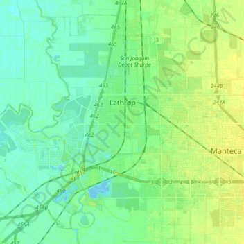
Name: Lathrop topographic map, elevation, terrain.
Location: Lathrop, San Joaquin County, California, United States (37.75979 -121.41428 37.86601 -121.26161)
Average elevation: 7 m
Minimum elevation: -4 m
Maximum elevation: 15 m
Other topographic maps
Click on a map to view its topography, its elevation and its terrain.