
Thank you for supporting this site ❤️
Make a donation
Make a donation
Gear up for your next adventure:
As an Amazon Associate, this site earns from qualifying purchases at no extra cost to you.
Maceiras topographic map
Click on the map to display elevation.
Thank you for supporting this site ❤️
Make a donation
Make a donation
Gear up for your next adventure:
As an Amazon Associate, this site earns from qualifying purchases at no extra cost to you.
About this map
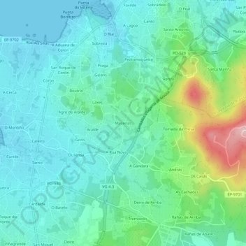
Name: Maceiras topographic map, elevation, terrain.
Average elevation: 53 m
Minimum elevation: -2 m
Maximum elevation: 238 m
Thank you for supporting this site ❤️
Make a donation
Make a donation
Gear up for your next adventure:
As an Amazon Associate, this site earns from qualifying purchases at no extra cost to you.
Other topographic maps
Click on a map to view its topography, its elevation and its terrain.
Parque Nacional Marítimo Terrestre das Ilhas Atlânticas da Galiza
Espanha > Galiza > O Salnés > Vilagarcía de Arousa
Average elevation: 47 m