
Valley of the happy people topographic map
Interactive map
Click on the map to display elevation.
About this map
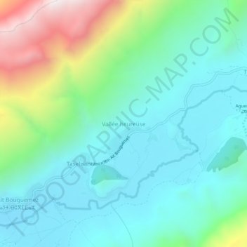
Name: Valley of the happy people topographic map, elevation, terrain.
Average elevation: 2,080 m
Minimum elevation: 1,777 m
Maximum elevation: 2,998 m
Other topographic maps
Click on a map to view its topography, its elevation and its terrain.
Ait Bouguemez
Maroc > cercle d'Azilal > Tabant
Ait Bouguemez, Tabant, caïdat de Tabant, cercle d'Azilal, Province d'Azilal, Béni Mellal-Khénifra, Maroc
Average elevation: 2,057 m
Imélghas
Maroc > cercle d'Azilal > Tabant
Imélghas, Tabant, caïdat de Tabant, cercle d'Azilal, Province d'Azilal, Béni Mellal-Khénifra, 22450, Maroc
Average elevation: 1,984 m
Ait Ouham
Maroc > cercle d'Azilal > Tabant
Ait Ouham, Tabant, caïdat de Tabant, cercle d'Azilal, Province d'Azilal, Béni Mellal-Khénifra, Maroc
Average elevation: 2,311 m