
Make a donation
Gear up for your next adventure:
As an Amazon Associate, this site earns from qualifying purchases at no extra cost to you.
Ford City topographic map
Click on the map to display elevation.
Make a donation
Gear up for your next adventure:
As an Amazon Associate, this site earns from qualifying purchases at no extra cost to you.
Ford City
Ford City is a census-designated place (CDP) in Kern County, California, United States. Ford City is located 1 mile (1.61 km) north of Taft, at an elevation of 892 feet (272 m). The population was 4,348 at the 2020 census, up from 4,278 at the 2010 census. It is immediately north of Taft, between the huge Midway-Sunset Oil Field to the southwest, and the almost exhausted Buena Vista Oil Field to the northeast. State Route 119 passes east of town from its junction with SR 33 to the south.
Make a donation
Gear up for your next adventure:
As an Amazon Associate, this site earns from qualifying purchases at no extra cost to you.
About this map
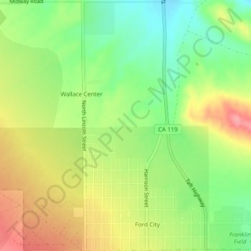
Name: Ford City topographic map, elevation, terrain.
Location: Ford City, Taft, Kern County, California, United States (35.15126 -119.46548 35.18064 -119.44785)
Average elevation: 264 m
Minimum elevation: 219 m
Maximum elevation: 314 m
Make a donation
Gear up for your next adventure:
As an Amazon Associate, this site earns from qualifying purchases at no extra cost to you.