Geolocate

Mondariz topographic map

Click on the map to display elevation.

About this map

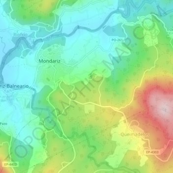
Name: Mondariz topographic map, elevation, terrain.

Location: Mondariz, Condado, Pontevedra, Galicia, España (42.21131 -8.46859 42.24479 -8.42327)

Average elevation: 151 m

Minimum elevation: 44 m

Maximum elevation: 373 m

Gear up for your next adventure:

💡Solar Camping Lamp - Eco-friendly lighting for campsites
🥾Waterproof Trail Shoes - Shoes designed to handle wet terrain
Camping Tent - Weather-resistant tents suitable for 2 to 6 people
🛰️Satellite Messenger - Emergency communication for areas with no cell service
🥾Light Trekking Boots - Supportive boots for multi-day treks

As an Amazon Associate, this site earns from qualifying purchases at no extra cost to you.