
La Libertad topographic map
Interactive map
Click on the map to display elevation.
About this map
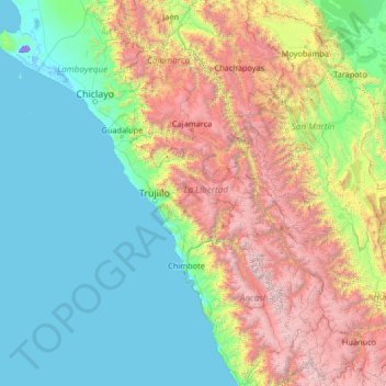
Name: La Libertad topographic map, elevation, terrain.
Location: La Libertad, Peru (-10.60000 -81.10000 -5.40000 -75.90000)
Average elevation: 1,247 m
Minimum elevation: -25 m
Maximum elevation: 6,229 m
Other topographic maps
Click on a map to view its topography, its elevation and its terrain.
Huaylillas
Peru > La Libertad > Huaylillas
Huaylillas, Pataz, La Libertad, Peru
Average elevation: 3,261 m
La Ramada
Peru > La Libertad > Cungunday > La Ramada
La Ramada, Cungunday, Charat, Otuzco, La Libertad, Peru
Average elevation: 3,181 m