
Make a donation
Gear up for your next adventure:
As an Amazon Associate, this site earns from qualifying purchases at no extra cost to you.
Westvale topographic map
Click on the map to display elevation.
Make a donation
Gear up for your next adventure:
As an Amazon Associate, this site earns from qualifying purchases at no extra cost to you.
About this map
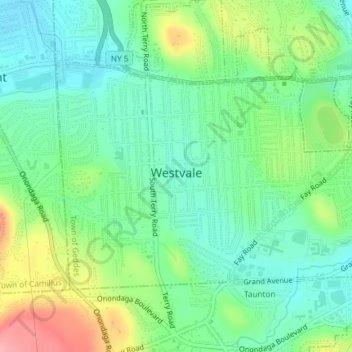
Name: Westvale topographic map, elevation, terrain.
Average elevation: 168 m
Minimum elevation: 131 m
Maximum elevation: 244 m
Make a donation
Gear up for your next adventure:
As an Amazon Associate, this site earns from qualifying purchases at no extra cost to you.
Other topographic maps
Click on a map to view its topography, its elevation and its terrain.
Skaneateles Lake
United States > New York > Onondaga County > Town of Skaneateles
Skaneateles Lake (/ˌskæniˈætləs/ SKAN-ee-AT-ləs, locally /ˌskɪn-/ SKIN-) is one of the Finger Lakes in central New York in the United States. The name Skaneateles means long lake in one of the local Iroquoian languages. The lake is sometimes referred to as "The Roof Garden of the Lakes" because its…
Average elevation: 349 m
Make a donation
Gear up for your next adventure:
As an Amazon Associate, this site earns from qualifying purchases at no extra cost to you.
Skanondaga Heights
United States > New York > Onondaga County > Town of Skaneateles
Average elevation: 291 m
Onondaga Hill
United States > New York > Onondaga County > Town of Onondaga > Onondaga Hill
Average elevation: 243 m
Make a donation
Gear up for your next adventure:
As an Amazon Associate, this site earns from qualifying purchases at no extra cost to you.
Spafford Valley
United States > New York > Onondaga County > Town of Spafford
Average elevation: 385 m
Make a donation
Gear up for your next adventure:
As an Amazon Associate, this site earns from qualifying purchases at no extra cost to you.
Howlett Hill
United States > New York > Onondaga County > Town of Onondaga > Howlett Hill
Average elevation: 271 m
Borodino
United States > New York > Onondaga County > Town of Spafford > Borodino
Average elevation: 327 m
Pitcher Hill
United States > New York > Onondaga County > Town of Salina > Pitcher Hill
Average elevation: 127 m
Heath Grove
United States > New York > Onondaga County > Town of Otisco > Heath Grove
Average elevation: 294 m
Make a donation
Gear up for your next adventure:
As an Amazon Associate, this site earns from qualifying purchases at no extra cost to you.
Stiles
United States > New York > Onondaga County > Town of Van Buren > Stiles
Average elevation: 130 m