Geolocate

Grazalema topographic map

Click on the map to display elevation.

About this map

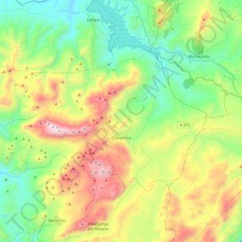
Name: Grazalema topographic map, elevation, terrain.

Location: Grazalema, Sierra de Cádiz, Cádiz, Andalusia, Spain (36.72056 -5.50151 36.81942 -5.29093)

Average elevation: 771 m

Minimum elevation: 281 m

Maximum elevation: 1,622 m

Gear up for your next adventure:

🧥Packable Rain Jacket - Breathable waterproof layer for unpredictable weather
🕶️Polarized Sunglasses - Protect your eyes with durable polarized lenses
🥾Mountaineering Boots - Supportive boots for climbing and high-altitude hiking
🧭GPS Tracker - Track your location in remote areas safely
👟Sport Hiking Sandals - Breathable footwear for water crossings and camp rest

As an Amazon Associate, this site earns from qualifying purchases at no extra cost to you.