
Make a donation
Gear up for your next adventure:
As an Amazon Associate, this site earns from qualifying purchases at no extra cost to you.
Musina Local Municipality topographic map
Click on the map to display elevation.
Make a donation
Gear up for your next adventure:
As an Amazon Associate, this site earns from qualifying purchases at no extra cost to you.
About this map
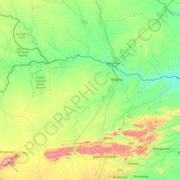
Name: Musina Local Municipality topographic map, elevation, terrain.
Average elevation: 692 m
Minimum elevation: 356 m
Maximum elevation: 2,041 m
Make a donation
Gear up for your next adventure:
As an Amazon Associate, this site earns from qualifying purchases at no extra cost to you.
Other topographic maps
Click on a map to view its topography, its elevation and its terrain.
Thohoyandou
South Africa > Limpopo > Vhembe District Municipality > Thulamela Local Municipality
Average elevation: 632 m
Malamulele
South Africa > Limpopo > Vhembe District Municipality > Thulamela Local Municipality
Average elevation: 542 m
Mashamba
South Africa > Limpopo > Vhembe District Municipality > Makhado Local Municipality
Average elevation: 587 m
Make a donation
Gear up for your next adventure:
As an Amazon Associate, this site earns from qualifying purchases at no extra cost to you.
Phiphidi Waterfall
South Africa > Limpopo > Vhembe District Municipality > Thulamela Local Municipality
Average elevation: 781 m
Thononda
South Africa > Limpopo > Vhembe District Municipality > Mutale Local Municipality
Average elevation: 1,295 m
Folovhodwe
South Africa > Limpopo > Vhembe District Municipality > Mutale Local Municipality
Average elevation: 523 m
Manyii
South Africa > Limpopo > Vhembe District Municipality > Makhado Local Municipality
Average elevation: 912 m
Make a donation
Gear up for your next adventure:
As an Amazon Associate, this site earns from qualifying purchases at no extra cost to you.
Valdezia
South Africa > Limpopo > Vhembe District Municipality > Makhado Local Municipality
Average elevation: 737 m
Chillas
South Africa > Limpopo > Vhembe District Municipality > Thulamela Local Municipality
Average elevation: 445 m
Mbhokota Village
South Africa > Limpopo > Vhembe District Municipality > Makhado Local Municipality
Average elevation: 792 m
Make a donation
Gear up for your next adventure:
As an Amazon Associate, this site earns from qualifying purchases at no extra cost to you.
Malavuwe
South Africa > Limpopo > Vhembe District Municipality > Thulamela Local Municipality
Average elevation: 522 m
Dzanani
South Africa > Limpopo > Vhembe District Municipality > Makhado Local Municipality
Average elevation: 833 m
Nandoni Dam
South Africa > Limpopo > Vhembe District Municipality > Thulamela Local Municipality
Average elevation: 503 m
Mtititi
South Africa > Limpopo > Vhembe District Municipality > Thulamela Local Municipality
Average elevation: 475 m
Make a donation
Gear up for your next adventure:
As an Amazon Associate, this site earns from qualifying purchases at no extra cost to you.
Tshipise
South Africa > Limpopo > Vhembe District Municipality > Mutale Local Municipality
Average elevation: 470 m
Mutale
South Africa > Limpopo > Vhembe District Municipality > Mutale Local Municipality
Average elevation: 755 m
Valdezia
South Africa > Limpopo > Vhembe District Municipality > Makhado Local Municipality
Average elevation: 737 m
Make a donation
Gear up for your next adventure:
As an Amazon Associate, this site earns from qualifying purchases at no extra cost to you.
Mutale
South Africa > Limpopo > Vhembe District Municipality > Thulamela Local Municipality
Average elevation: 1,016 m
Phiphidi Waterfall
South Africa > Limpopo > Vhembe District Municipality > Thulamela Local Municipality
Average elevation: 781 m
Elim
South Africa > Limpopo > Vhembe District Municipality > Makhado Local Municipality
Average elevation: 869 m
Thohoyandou
South Africa > Limpopo > Vhembe District Municipality > Thulamela Local Municipality
Average elevation: 632 m
Make a donation
Gear up for your next adventure:
As an Amazon Associate, this site earns from qualifying purchases at no extra cost to you.
Thohoyandou
South Africa > Limpopo > Vhembe District Municipality > Thulamela Local Municipality
Average elevation: 632 m
Malamulele
South Africa > Limpopo > Vhembe District Municipality > Thulamela Local Municipality
Average elevation: 542 m
Phiphidi Waterfall
South Africa > Limpopo > Vhembe District Municipality > Thulamela Local Municipality
Average elevation: 781 m
Phiphidi Waterfall
South Africa > Limpopo > Vhembe District Municipality > Thulamela Local Municipality
Average elevation: 784 m
Make a donation
Gear up for your next adventure:
As an Amazon Associate, this site earns from qualifying purchases at no extra cost to you.
Nandoni Dam
South Africa > Limpopo > Vhembe District Municipality > Thulamela Local Municipality
Average elevation: 503 m
Jimmy Jones, South Africa
South Africa > Limpopo > Vhembe District Municipality > Thulamela Local Municipality
Average elevation: 548 m
Masisi
South Africa > Limpopo > Vhembe District Municipality > Mutale Local Municipality
Average elevation: 381 m
Mtititi
South Africa > Limpopo > Vhembe District Municipality > Thulamela Local Municipality
Average elevation: 475 m
Make a donation
Gear up for your next adventure:
As an Amazon Associate, this site earns from qualifying purchases at no extra cost to you.
Dzanani
South Africa > Limpopo > Vhembe District Municipality > Makhado Local Municipality
Average elevation: 833 m
Beit Bridge
South Africa > Limpopo > Vhembe District Municipality > Musina Local Municipality
Average elevation: 452 m
Make a donation
Gear up for your next adventure:
As an Amazon Associate, this site earns from qualifying purchases at no extra cost to you.
Chavani
South Africa > Limpopo > Vhembe District Municipality > Makhado Local Municipality
Average elevation: 745 m
Thononda
South Africa > Limpopo > Vhembe District Municipality > Mutale Local Municipality
Average elevation: 1,295 m