
Beaucaire topographic map
Interactive map
Click on the map to display elevation.
About this map
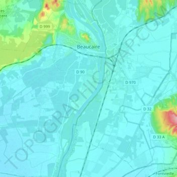
Name: Beaucaire topographic map, elevation, terrain.
Average elevation: 15 m
Minimum elevation: 0 m
Maximum elevation: 164 m
Other topographic maps
Click on a map to view its topography, its elevation and its terrain.
Mont Fleuri
França > Occitânia > Gard > Trèves
Mont Fleuri, Trèves, Le Vigan, Gard, Occitânia, França metropolitana, 30750, França
Average elevation: 807 m
Aigues-Mortes
França > Occitânia > Gard > Aigues-Mortes
Aigues-Mortes, Nîmes, Gard, Occitânia, França metropolitana, 30220, França
Average elevation: 0 m