Geolocate

Hat Yai topographic map

Click on the map to display elevation.

About this map

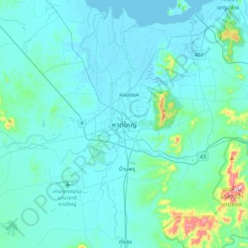
Name: Hat Yai topographic map, elevation, terrain.

Location: Hat Yai, Kho Hong, Hat Yai, Songkhla Province, Thailand (6.84746 100.30899 7.16746 100.62899)

Average elevation: 47 m

Minimum elevation: -2 m

Maximum elevation: 524 m

Gear up for your next adventure:

🦯Trekking Poles - Reduced impact on joints for steep topographic climbs
🛶Kayak Accessories - Essential gear for safe and fun kayaking adventures
🔥Emergency Fire Starter - Reliable ignition source for all weather conditions
🥤Collapsible Travel Cup - Saves space and weight in your mess kit
🥾Lightweight Hiking Boots - Boots for comfort and mobility on long hikes

As an Amazon Associate, this site earns from qualifying purchases at no extra cost to you.