
Make a donation
Gear up for your next adventure:
As an Amazon Associate, this site earns from qualifying purchases at no extra cost to you.
Stockum topographic map
Click on the map to display elevation.
Make a donation
Gear up for your next adventure:
As an Amazon Associate, this site earns from qualifying purchases at no extra cost to you.
Stockum
Stockum befindet sich etwa 2 km nordöstlich von Körbecke, dem Zentralort der Gemeinde. Der Ort liegt am Nordufer des Möhnesees auf halber Höhe des Haarstranges.
Make a donation
Gear up for your next adventure:
As an Amazon Associate, this site earns from qualifying purchases at no extra cost to you.
About this map
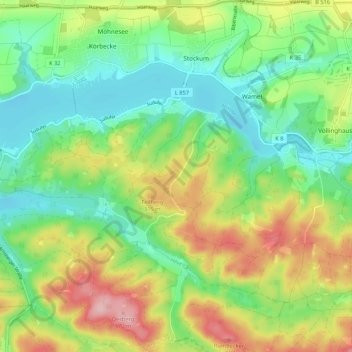
Name: Stockum topographic map, elevation, terrain.
Location: Stockum, Möhnesee, Kreis Soest, Nordrhein-Westfalen, Deutschland (51.43978 8.13678 51.50579 8.17418)
Average elevation: 272 m
Minimum elevation: 208 m
Maximum elevation: 378 m
Make a donation
Gear up for your next adventure:
As an Amazon Associate, this site earns from qualifying purchases at no extra cost to you.
Other topographic maps
Click on a map to view its topography, its elevation and its terrain.