
Rohrberg topographic map
Interactive map
Click on the map to display elevation.
About this map
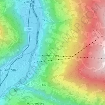
Name: Rohrberg topographic map, elevation, terrain.
Location: Rohrberg, Bezirk Schwaz, Tyrol, 6280, Autriche (47.22624 11.89234 47.25677 11.96184)
Average elevation: 1,317 m
Minimum elevation: 561 m
Maximum elevation: 2,272 m
Other topographic maps
Click on a map to view its topography, its elevation and its terrain.
Laimach
Autriche > Tyrol > Bezirk Schwaz > Gemeinde Hippach
Laimach, Gemeinde Hippach, Bezirk Schwaz, Tyrol, 6283, Autriche
Average elevation: 902 m
Finkenberg
Autriche > Tyrol > Bezirk Schwaz
Finkenberg, Bezirk Schwaz, Tyrol, 6292, Autriche
Average elevation: 2,088 m
Dorf-Haus
Autriche > Tyrol > Bezirk Schwaz > Mayrhofen
Dorf-Haus, Mayrhofen, Bezirk Schwaz, Tyrol, 6290, Autriche
Average elevation: 1,028 m
Schwaz
Autriche > Tyrol > Bezirk Schwaz
Schwaz, Stadt Schwaz, Bezirk Schwaz, Tyrol, 6130, Autriche
Average elevation: 951 m
Gemeinde Gerlos
Autriche > Tyrol > Bezirk Schwaz > Gemeinde Gerlos
Gemeinde Gerlos, Bezirk Schwaz, Tyrol, 6281, Autriche
Average elevation: 1,911 m
Hochiss
Autriche > Tyrol > Bezirk Schwaz > Gemeinde Steinberg am Rofan
Hochiss, Gemeinde Steinberg am Rofan, Bezirk Schwaz, Tyrol, 6212, Autriche
Average elevation: 1,884 m
Marktgemeinde Mayrhofen
Autriche > Tyrol > Bezirk Schwaz
Marktgemeinde Mayrhofen, Bezirk Schwaz, Tyrol, Autriche
Average elevation: 1,983 m
Schwendau
Autriche > Tyrol > Bezirk Schwaz
Schwendau, Bezirk Schwaz, Tyrol, Autriche
Average elevation: 1,459 m
Vomp
Autriche > Tyrol > Bezirk Schwaz
Vomp, Bezirk Schwaz, Tyrol, 6134, Autriche
Average elevation: 1,561 m
Eben am Achensee
Autriche > Tyrol > Bezirk Schwaz > Eben am Achensee
Eben am Achensee, Bezirk Schwaz, Tyrol, Autriche
Average elevation: 1,038 m
Kellerjochhütte
Autriche > Tyrol > Bezirk Schwaz
Kellerjochhütte, 67, Alpinsteig, Stadt Schwaz, Bezirk Schwaz, Tyrol, 6130, Autriche
Average elevation: 1,875 m
Greizer Hütte
Autriche > Tyrol > Bezirk Schwaz > Marktgemeinde Mayrhofen
Greizer Hütte, 300, Marktgemeinde Mayrhofen, Bezirk Schwaz, Tyrol, 6295, Autriche
Average elevation: 2,356 m