Geolocate

Pantukan topographic map

Click on the map to display elevation.

About this map

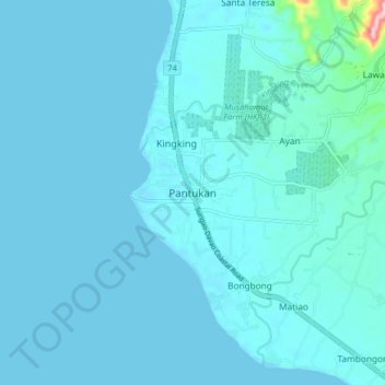
Name: Pantukan topographic map, elevation, terrain.

Location: Pantukan, Davao de Oro, Davao Region, 8809, Philippines (7.08682 125.85714 7.16682 125.93714)

Average elevation: 13 m

Minimum elevation: 0 m

Maximum elevation: 219 m

Other topographic maps

Click on a map to view its topography, its elevation and its terrain.

New Bataan

Philippines > Davao de Oro

Average elevation: 749 m

Laak

Philippines > Davao de Oro

Average elevation: 169 m

Gear up for your next adventure:

🔨Vehicle Emergency Tool - Safety tool for remote road trips to trailheads
🥾Mountain Hiking Shoes - Shoes with superior grip for mountainous terrain
🧥Waterproof Hiking Jacket - Protect yourself from rain and wind while hiking
🧤Insulated Winter Gloves - Heavy-duty protection for sub-zero Canadian adventures
🥾Lightweight Hiking Boots - Boots for comfort and mobility on long hikes

As an Amazon Associate, this site earns from qualifying purchases at no extra cost to you.