
Make a donation
Gear up for your next adventure:
As an Amazon Associate, this site earns from qualifying purchases at no extra cost to you.
Brückl topographic map
Click on the map to display elevation.
Make a donation
Gear up for your next adventure:
As an Amazon Associate, this site earns from qualifying purchases at no extra cost to you.
About this map
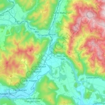
Name: Brückl topographic map, elevation, terrain.
Average elevation: 717 m
Minimum elevation: 447 m
Maximum elevation: 1,274 m
Make a donation
Gear up for your next adventure:
As an Amazon Associate, this site earns from qualifying purchases at no extra cost to you.
Other topographic maps
Click on a map to view its topography, its elevation and its terrain.
Silbereggerberg
Österreich > Kärnten > Bezirk Sankt Veit an der Glan > Silberegg
Average elevation: 684 m
Kleinglödnitz
Österreich > Kärnten > Bezirk Sankt Veit an der Glan > Glödnitz
Average elevation: 835 m
Mellach
Österreich > Kärnten > Bezirk Sankt Veit an der Glan > Straßburg > Mellach
Average elevation: 759 m
Bergwerksgraben
Österreich > Kärnten > Bezirk Sankt Veit an der Glan > Mölbling
Average elevation: 742 m
Make a donation
Gear up for your next adventure:
As an Amazon Associate, this site earns from qualifying purchases at no extra cost to you.