Geolocate

Midway topographic map

Click on the map to display elevation.

About this map

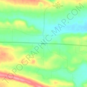
Name: Midway topographic map, elevation, terrain.

Location: Midway, Logan County, Arkansas, United States (35.27148 -93.54741 35.31148 -93.50741)

Average elevation: 167 m

Minimum elevation: 124 m

Maximum elevation: 232 m

Other topographic maps

Click on a map to view its topography, its elevation and its terrain.

Caulksville

United States > Arkansas > Logan County

Average elevation: 122 m

Ratcliff

United States > Arkansas > Logan County

Average elevation: 138 m

Scranton

United States > Arkansas > Logan County

Average elevation: 116 m

Subiaco

United States > Arkansas > Logan County

Average elevation: 146 m

Morrison Bluff

United States > Arkansas > Logan County

Average elevation: 112 m

Gear up for your next adventure:

🪑Ultralight Camping Stool - Compact seating for rest stops during long hikes
🔋Emergency Crank Radio - Weather alerts and power without needing batteries
🕶️Polarized Sunglasses - Protect your eyes with durable polarized lenses
🧢Hiking Sun Hat - Wide-brimmed protection for exposed mountain ridges
👖Convertible Hiking Pants - Zip-off legs to adapt to changing weather conditions

As an Amazon Associate, this site earns from qualifying purchases at no extra cost to you.