
Make a donation
Gear up for your next adventure:
As an Amazon Associate, this site earns from qualifying purchases at no extra cost to you.
Ploubalay topographic map
Click on the map to display elevation.
Make a donation
Gear up for your next adventure:
As an Amazon Associate, this site earns from qualifying purchases at no extra cost to you.
Ploubalay
Le château d'eau s'élève à 104 m d'altitude, ce qui fait un édifice d'une hauteur de 57 m. La peinture rouge en dessous signifie qu'il sert de repère et point d'entrée ouest pour le circuit d'approche de l'aéroport de Saint-Malo-Dinard-Pleurtuit situé à proximité.
Make a donation
Gear up for your next adventure:
As an Amazon Associate, this site earns from qualifying purchases at no extra cost to you.
About this map
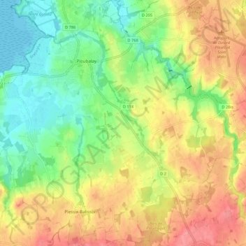
Name: Ploubalay topographic map, elevation, terrain.
Average elevation: 39 m
Minimum elevation: 0 m
Maximum elevation: 82 m
Make a donation
Gear up for your next adventure:
As an Amazon Associate, this site earns from qualifying purchases at no extra cost to you.
Other topographic maps
Click on a map to view its topography, its elevation and its terrain.
Make a donation
Gear up for your next adventure:
As an Amazon Associate, this site earns from qualifying purchases at no extra cost to you.
La Ravillais
France > Bretagne > Côtes-d'Armor > Beaussais-sur-Mer > Ploubalay
Average elevation: 33 m