
Make a donation
Gear up for your next adventure:
As an Amazon Associate, this site earns from qualifying purchases at no extra cost to you.
Duben topographic map
Click on the map to display elevation.
Make a donation
Gear up for your next adventure:
As an Amazon Associate, this site earns from qualifying purchases at no extra cost to you.
About this map
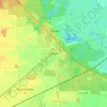
Name: Duben topographic map, elevation, terrain.
Location: Duben, Luckau, Dahme-Spreewald, Brandenburg, Deutschland (51.87778 13.78707 51.91778 13.82707)
Average elevation: 64 m
Minimum elevation: 48 m
Maximum elevation: 79 m
Make a donation
Gear up for your next adventure:
As an Amazon Associate, this site earns from qualifying purchases at no extra cost to you.
Other topographic maps
Click on a map to view its topography, its elevation and its terrain.
Fürstlich Drehna
Deutschland > Brandenburg > Dahme-Spreewald > Luckau
Die Wüste Kirche befand sich nordöstlich von Fürstlich Drehna. Unklarheiten bestanden, wie alt der Bau ist, welche Funktion er hatte und warum er aufgelassen wurde. Datiert wird er aber in die Zeit zwischen 1200 und 1300. Die Reste dieser Kirche fielen dem Braunkohletagebau zum Opfer und wurden im Oktober…
Average elevation: 79 m
Make a donation
Gear up for your next adventure:
As an Amazon Associate, this site earns from qualifying purchases at no extra cost to you.