Geolocate

Mathilakam topographic map

Click on the map to display elevation.

About this map

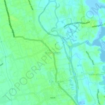
Name: Mathilakam topographic map, elevation, terrain.

Location: Mathilakam, Kodungallur, Thrissur, Kerala, 680685, India (10.26825 76.14938 10.30825 76.18938)

Average elevation: 5 m

Minimum elevation: -4 m

Maximum elevation: 10 m

Gear up for your next adventure:

🧴Sunscreen SPF - Broad-spectrum sunscreen for outdoor activities
🧥Waterproof Hiking Jacket - Protect yourself from rain and wind while hiking
🧼Travel Hand Sanitizer - Keep hands clean when water is scarce
🎒Backpack Rain Cover - External shield to keep your entire pack dry
🧊Insulated Water Bottle - Keeps drinks cold in summer and prevents freezing in winter

As an Amazon Associate, this site earns from qualifying purchases at no extra cost to you.