
Make a donation
Gear up for your next adventure:
As an Amazon Associate, this site earns from qualifying purchases at no extra cost to you.
Nienhaus topographic map
Click on the map to display elevation.
Make a donation
Gear up for your next adventure:
As an Amazon Associate, this site earns from qualifying purchases at no extra cost to you.
About this map
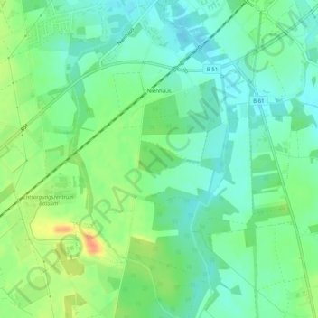
Name: Nienhaus topographic map, elevation, terrain.
Location: Nienhaus, Bassum, Landkreis Diepholz, Niedersachsen, Deutschland (52.81350 8.70609 52.84364 8.73104)
Average elevation: 46 m
Minimum elevation: 30 m
Maximum elevation: 74 m
Make a donation
Gear up for your next adventure:
As an Amazon Associate, this site earns from qualifying purchases at no extra cost to you.
Other topographic maps
Click on a map to view its topography, its elevation and its terrain.
Fesenfeld
Deutschland > Niedersachsen > Landkreis Diepholz > Bassum > Nordwohlde
Average elevation: 33 m
Make a donation
Gear up for your next adventure:
As an Amazon Associate, this site earns from qualifying purchases at no extra cost to you.