
Make a donation
Gear up for your next adventure:
As an Amazon Associate, this site earns from qualifying purchases at no extra cost to you.
Lava Butte topographic map
Click on the map to display elevation.
Make a donation
Gear up for your next adventure:
As an Amazon Associate, this site earns from qualifying purchases at no extra cost to you.
About this map
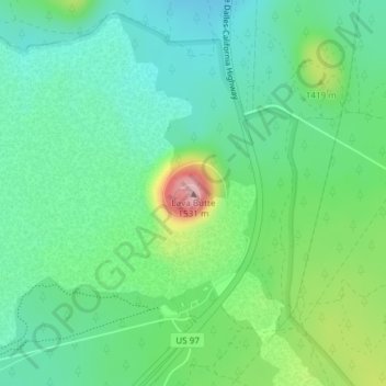
Name: Lava Butte topographic map, elevation, terrain.
Location: Lava Butte, Deschutes County, Oregon, United States (43.91756 -121.35598 43.91766 -121.35588)
Average elevation: 1,365 m
Minimum elevation: 1,306 m
Maximum elevation: 1,510 m
Make a donation
Gear up for your next adventure:
As an Amazon Associate, this site earns from qualifying purchases at no extra cost to you.
Other topographic maps
Click on a map to view its topography, its elevation and its terrain.
Archie Briggs Canyon Natural Area
United States > Oregon > Deschutes County > Bend
Average elevation: 1,115 m
Make a donation
Gear up for your next adventure:
As an Amazon Associate, this site earns from qualifying purchases at no extra cost to you.