
Make a donation
Gear up for your next adventure:
As an Amazon Associate, this site earns from qualifying purchases at no extra cost to you.
Rühle topographic map
Click on the map to display elevation.
Make a donation
Gear up for your next adventure:
As an Amazon Associate, this site earns from qualifying purchases at no extra cost to you.
About this map
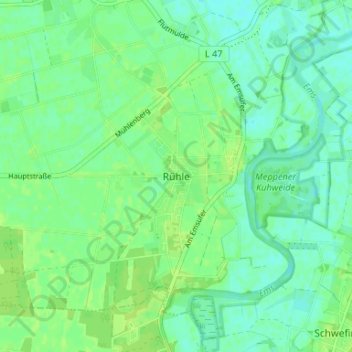
Name: Rühle topographic map, elevation, terrain.
Average elevation: 16 m
Minimum elevation: 10 m
Maximum elevation: 22 m
Make a donation
Gear up for your next adventure:
As an Amazon Associate, this site earns from qualifying purchases at no extra cost to you.
Other topographic maps
Click on a map to view its topography, its elevation and its terrain.
Make a donation
Gear up for your next adventure:
As an Amazon Associate, this site earns from qualifying purchases at no extra cost to you.
Teglingen
Deutschland > Niedersachsen > Landkreis Emsland > Meppen
In den 1950er Jahren wurde der Dortmund-Ems-Kanal ausgebaut. Bei Teglingen wurde eine neue Schleusengruppe gebaut (zwei Schleusen von 165 m und 100 m Nutzlänge; Fallhöhe 7,5 m), damit die alte Kanalstufe Meppen entfallen konnte.
Average elevation: 17 m
Make a donation
Gear up for your next adventure:
As an Amazon Associate, this site earns from qualifying purchases at no extra cost to you.