Geolocate

Pic Eccles topographic map

Click on the map to display elevation.

About this map

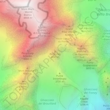
Name: Pic Eccles topographic map, elevation, terrain.

Location: Pic Eccles, Courmayeur, Aosta Valley, Italy (45.82163 6.87450 45.82173 6.87460)

Average elevation: 3,722 m

Minimum elevation: 2,677 m

Maximum elevation: 4,804 m

Gear up for your next adventure:

Camping Essentials - All-in-one gear for a comfortable camping trip
🔨Vehicle Emergency Tool - Safety tool for remote road trips to trailheads
Backpacking Tent - Lightweight tent for long-distance hiking trips
👟Sport Hiking Sandals - Breathable footwear for water crossings and camp rest
🧢Outdoor Visor - Breathable visor for sunny hikes

As an Amazon Associate, this site earns from qualifying purchases at no extra cost to you.