Geolocate

Alupidian topographic map

Click on the map to display elevation.

About this map

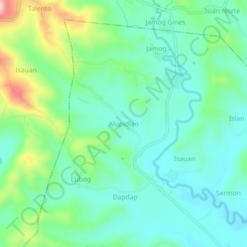
Name: Alupidian topographic map, elevation, terrain.

Location: Alupidian, Iloilo, Western Visayas, 5027, Philippines (10.72878 122.33007 10.76878 122.37007)

Average elevation: 93 m

Minimum elevation: 28 m

Maximum elevation: 273 m

Other topographic maps

Click on a map to view its topography, its elevation and its terrain.

Barotac Nuevo

Philippines > Iloilo

Average elevation: 15 m

Barotac Viejo

Philippines > Iloilo

Average elevation: 80 m

Leganes

Philippines > Iloilo

Average elevation: 9 m

Ajuy

Philippines > Iloilo

Average elevation: 42 m

Dumangas

Philippines > Iloilo

Average elevation: 8 m

San Dionisio

Philippines > Iloilo

Average elevation: 64 m

Lambunao

Philippines > Iloilo

Average elevation: 127 m

Pavia

Philippines > Iloilo

Average elevation: 16 m

Savannah Subdivision

Philippines > Iloilo > Oton > Abilay Norte

Average elevation: 16 m

Panay

Philippines > Iloilo

Panay island is the sixth largest island in the Philippines by area, with a total land area of 12,011 km2 (4,637 sq mi). Mount Madja-as is the highest point in Panay with an elevation of 2,117 metres (6,946 ft) above sea level, located in town of Culasi in the northern province of Antique. Central Panay…

Average elevation: 117 m

Batad

Philippines > Iloilo

Average elevation: 56 m

Guimbal

Philippines > Iloilo

Guimbal, a coastal municipality, is located at the south-western part of Iloilo province. It is situated between the coordinates of 1250 57’ longitude, and 100 39’ latitude. It is 29 kilometres (18 mi) from Iloilo City, and has a total land area of 4,461 hectares (11,020 acres). It is only six feet above…

Average elevation: 27 m

Magapa

Philippines > Iloilo > Damires

Average elevation: 67 m

Guimbal

Philippines > Iloilo

Guimbal, a coastal municipality, is located at the south-western part of Iloilo province. It is situated between the coordinates of 1250 57’ longitude, and 100 39’ latitude. It is 29 kilometres (18 mi) from Iloilo City, and has a total land area of 4,461 hectares (11,020 acres). It is only six feet above…

Average elevation: 27 m

San Dionisio

Philippines > Iloilo

Average elevation: 64 m

Oton

Philippines > Iloilo

Average elevation: 12 m

Estancia

Philippines > Iloilo

Average elevation: 11 m

Miagao

Philippines > Iloilo

Average elevation: 97 m

San Joaquin

Philippines > Iloilo

Average elevation: 75 m

Tigbauan

Philippines > Iloilo

Average elevation: 23 m

Zarraga

Philippines > Iloilo

Average elevation: 10 m

Carles

Philippines > Iloilo

Average elevation: 20 m

Concepcion

Philippines > Iloilo

Average elevation: 48 m

Pavia

Philippines > Iloilo

Average elevation: 15 m

Iloilo River

Philippines > Iloilo > Oton > Pakiad > Linstle Ville

Average elevation: 5 m

Danao Lake

Philippines > Iloilo > Dao

Average elevation: 488 m

Bucari Pine Forest

Philippines > Iloilo > Camandag

Average elevation: 705 m

Jarao River

Philippines > Iloilo > Guimbal > Sipitan-Badlang

Average elevation: 67 m

Plaza Pavia

Philippines > Iloilo > Pavia > Purok III

Average elevation: 17 m

Barotac Nuevo

Philippines > Iloilo

Average elevation: 15 m

Oton

Philippines > Iloilo

Average elevation: 11 m

Chico Island

Philippines > Iloilo > Concepcion > Malangabang

Average elevation: 6 m

San Joaquin

Philippines > Iloilo

Average elevation: 72 m

San Dionisio

Philippines > Iloilo

Average elevation: 64 m

Aganan River

Philippines > Iloilo > Pavia > Purok IV

Average elevation: 16 m

Magais Island

Philippines > Iloilo > Concepcion > Talotu-an

Average elevation: 2 m

Oton

Philippines > Iloilo

Average elevation: 11 m

Dumangas

Philippines > Iloilo

Average elevation: 8 m

Carles

Philippines > Iloilo

Average elevation: 20 m

Panay

Philippines > Iloilo

Panay island is the sixth largest island in the Philippines by area, with a total land area of 12,011 km2 (4,637 sq mi). Mount Madja-as is the highest point in Panay with an elevation of 2,117 metres (6,946 ft) above sea level, located in town of Culasi in the northern province of Antique. Central Panay…

Average elevation: 117 m

Tigbauan

Philippines > Iloilo

Average elevation: 23 m

San Joaquin

Philippines > Iloilo

Average elevation: 72 m

Magalumbi Island

Philippines > Iloilo > Batad

Average elevation: 0 m

Guimbal

Philippines > Iloilo

Guimbal, a coastal municipality, is located at the south-western part of Iloilo province. It is situated between the coordinates of 1250 57’ longitude, and 100 39’ latitude. It is 29 kilometres (18 mi) from Iloilo City, and has a total land area of 4,461 hectares (11,020 acres). It is only six feet above…

Average elevation: 27 m

Tigbauan

Philippines > Iloilo

Average elevation: 23 m

Jaro

Philippines > Iloilo > Iloilo City

Average elevation: 8 m

Guimbal

Philippines > Iloilo

Guimbal, a coastal municipality, is located at the south-western part of Iloilo province. It is situated between the coordinates of 1250 57’ longitude, and 100 39’ latitude. It is 29 kilometres (18 mi) from Iloilo City, and has a total land area of 4,461 hectares (11,020 acres). It is only six feet above…

Average elevation: 27 m

Ajuy

Philippines > Iloilo

Average elevation: 42 m

Panay

Philippines > Iloilo

Panay island is the sixth largest island in the Philippines by area, with a total land area of 12,011 km2 (4,637 sq mi). Mount Madja-as is the highest point in Panay with an elevation of 2,117 metres (6,946 ft) above sea level, located in town of Culasi in the northern province of Antique. Central Panay…

Average elevation: 117 m

Zarraga

Philippines > Iloilo

Average elevation: 10 m

Barotac Viejo

Philippines > Iloilo

Average elevation: 80 m

Tigbauan

Philippines > Iloilo

Average elevation: 23 m

Estancia

Philippines > Iloilo

Average elevation: 11 m

Concepcion

Philippines > Iloilo

Average elevation: 48 m

Gear up for your next adventure:

🧦Outdoor Socks - Durable socks designed for hiking and outdoor sports
🧊Insulated Water Bottle - Keeps drinks cold in summer and prevents freezing in winter
🛏️Sleeping Bag - Warm and compact sleeping bags for outdoor camping
🪑Ultralight Camping Stool - Compact seating for rest stops during long hikes
🔭Compact Binoculars - Lightweight optics for scouting trails and wildlife

As an Amazon Associate, this site earns from qualifying purchases at no extra cost to you.