
Make a donation
Gear up for your next adventure:
As an Amazon Associate, this site earns from qualifying purchases at no extra cost to you.
Tizgui topographic map
Click on the map to display elevation.
Make a donation
Gear up for your next adventure:
As an Amazon Associate, this site earns from qualifying purchases at no extra cost to you.
About this map
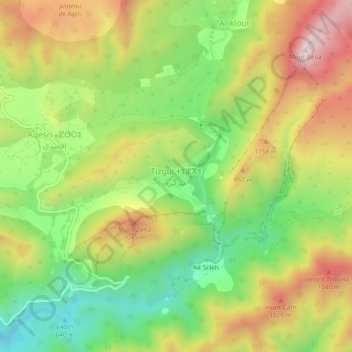
Name: Tizgui topographic map, elevation, terrain.
Average elevation: 834 m
Minimum elevation: 534 m
Maximum elevation: 1,187 m
Make a donation
Gear up for your next adventure:
As an Amazon Associate, this site earns from qualifying purchases at no extra cost to you.
Other topographic maps
Click on a map to view its topography, its elevation and its terrain.
Tamri
Maroc > cercle d'Agadir-Atlantique
La commune se trouve à environ 60 km au nord d'agadir avec une superficie de 868 km2 il est dominé par les montagnes de haut atlas qui atteignent 1700 mètres d'altitude et aussi l'océan Atlantique au long de l'ouest de la commune qui s'est considérée semi-aride il reçoit par an des précipitations qui…
Average elevation: 159 m
Make a donation
Gear up for your next adventure:
As an Amazon Associate, this site earns from qualifying purchases at no extra cost to you.