Geolocate

Dhundi topographic map

Click on the map to display elevation.

About this map

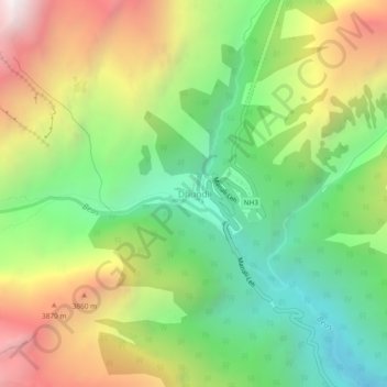
Name: Dhundi topographic map, elevation, terrain.

Location: Dhundi, Manali, Kullu, Himachal Pradesh, India (32.33427 77.10670 32.37427 77.14670)

Average elevation: 3,309 m

Minimum elevation: 2,560 m

Maximum elevation: 4,374 m

Gear up for your next adventure:

🧢Hiking Sun Hat - Wide-brimmed protection for exposed mountain ridges
🧣Evaporative Cooling Towel - Beat the heat during intense summer climbs
🥾Trekking Boots - Durable boots for long-distance trekking
🥾Mountain Trail Shoes - High-traction shoes for mountain trails
Backpacking Tent - Lightweight tent for long-distance hiking trips

As an Amazon Associate, this site earns from qualifying purchases at no extra cost to you.