Geolocate

Drury topographic map

Click on the map to display elevation.

About this map

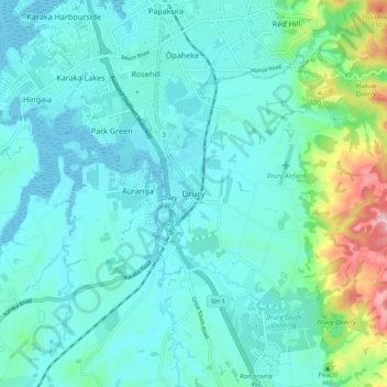
Name: Drury topographic map, elevation, terrain.

Location: Drury, Papakura, Auckland, 2113, New Zealand (-37.14207 174.91183 -37.06207 174.99183)

Average elevation: 46 m

Minimum elevation: 0 m

Maximum elevation: 273 m

Other topographic maps

Click on a map to view its topography, its elevation and its terrain.

Pararēkau Island

New Zealand > Auckland > Papakura

Average elevation: 8 m

Gear up for your next adventure:

🥾Lightweight Hiking Shoes - Comfortable shoes for day hikes
🧦Outdoor Socks - Durable socks designed for hiking and outdoor sports
🥾Hiking Shorts - Breathable shorts suitable for summer hikes
🥾Light Trekking Boots - Supportive boots for multi-day treks
🧼Biodegradable Camp Soap - Environmentally friendly cleaning for gear and body

As an Amazon Associate, this site earns from qualifying purchases at no extra cost to you.