
Angra dos Reis topographic map
Click on the map to display elevation.
About this map
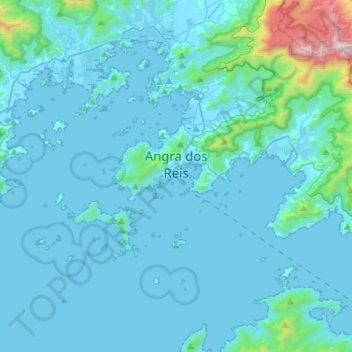
Name: Angra dos Reis topographic map, elevation, terrain.
Average elevation: 125 m
Minimum elevation: -1 m
Maximum elevation: 1,639 m
Other topographic maps
Click on a map to view its topography, its elevation and its terrain.
Barra da Tijuca
Brazil > Rio de Janeiro > Região Metropolitana do Rio de Janeiro > Rio de Janeiro
Average elevation: 4 m
Armação dos Búzios
Brazil > Rio de Janeiro > Armação dos Búzios > Armação dos Búzios
Average elevation: 5 m
Praia do Leblon
Brazil > Rio de Janeiro > Região Metropolitana do Rio de Janeiro > Rio de Janeiro
Average elevation: 26 m
Morro do Pinto
Brazil > Rio de Janeiro > Região Metropolitana do Rio de Janeiro > Rio de Janeiro
Average elevation: 11 m
Rio Cuiabá
Brazil > Rio de Janeiro > Região Metropolitana do Rio de Janeiro > Petrópolis
Average elevation: 926 m
Praça Jamal de Paula
Brazil > Rio de Janeiro > Região Metropolitana do Rio de Janeiro > Rio de Janeiro
Average elevation: 28 m