Geolocate

Aranza topographic map

Click on the map to display elevation.

About this map

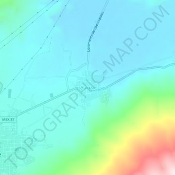
Name: Aranza topographic map, elevation, terrain.

Location: Aranza, Paracho, Michoacán, Mexico (19.64258 -102.04380 19.68258 -102.00380)

Average elevation: 2,259 m

Minimum elevation: 2,150 m

Maximum elevation: 2,749 m

Gear up for your next adventure:

🥾Lightweight Hiking Shoes - Comfortable shoes for day hikes
🧥Insulated Jacket - Keep warm in cold outdoor conditions
Camping Essentials - All-in-one gear for a comfortable camping trip
💧Hydration Bladder - Hands-free hydration solution for long treks
🥤Collapsible Travel Cup - Saves space and weight in your mess kit

As an Amazon Associate, this site earns from qualifying purchases at no extra cost to you.