Geolocate

Pansdorf topographic map

Click on the map to display elevation.

About this map

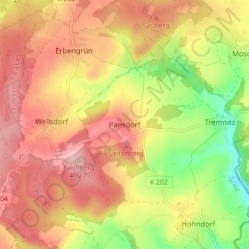
Name: Pansdorf topographic map, elevation, terrain.

Location: Pansdorf, Greiz, Thuringia, Germany (50.60855 12.09761 50.64855 12.13761)

Average elevation: 402 m

Minimum elevation: 308 m

Maximum elevation: 469 m

Other topographic maps

Click on a map to view its topography, its elevation and its terrain.

Weida

Germany > Thuringia > Greiz

Average elevation: 315 m

Großenstein

Germany > Thuringia > Greiz

Average elevation: 287 m

Greiz

Germany > Thuringia > Greiz

Average elevation: 380 m

Gear up for your next adventure:

🥾Mountaineering Boots - Supportive boots for climbing and high-altitude hiking
🚲Handlebar Phone Mount - View topographic-map.com live while cycling
🥾Mountain Hiking Shoes - Shoes with superior grip for mountainous terrain
🪑Insulated Seat Pad - Protect your seat from cold rocks and wet logs
🧴Waterproofing Spray - Restore the DWR coating on jackets and tents

As an Amazon Associate, this site earns from qualifying purchases at no extra cost to you.