Geolocate

Rubiales topographic map

Click on the map to display elevation.

About this map

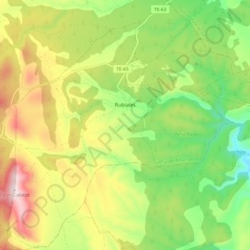
Name: Rubiales topographic map, elevation, terrain.

Location: Rubiales, Sierra de Albarracín, Teruel, Aragon, Spain (40.23655 -1.31437 40.30501 -1.23258)

Average elevation: 1,201 m

Minimum elevation: 990 m

Maximum elevation: 1,478 m

Other topographic maps

Click on a map to view its topography, its elevation and its terrain.

Caimodorro

Spain > Aragon > Sierra de Albarracín > Albarracín

Average elevation: 1,752 m

Muela de San Juan

Spain > Aragon > Sierra de Albarracín > Griegos

Average elevation: 1,735 m

Gear up for your next adventure:

🥾Mountain Trail Shoes - High-traction shoes for mountain trails
🧥Insulated Jacket - Keep warm in cold outdoor conditions
🥾Approach Boots - Comfortable boots for hiking and climbing approaches
🧭Orienteering Kit - Tools for map reading and navigation in the wild
🕶️Polarized Sunglasses - Protect your eyes with durable polarized lenses

As an Amazon Associate, this site earns from qualifying purchases at no extra cost to you.