Geolocate

Delod Peken topographic map

Click on the map to display elevation.

About this map

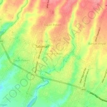
Name: Delod Peken topographic map, elevation, terrain.

Location: Delod Peken, Tabanan, Bali, 82114, Indonesia (-8.56191 115.11093 -8.52191 115.15093)

Average elevation: 118 m

Minimum elevation: 68 m

Maximum elevation: 159 m

Other topographic maps

Click on a map to view its topography, its elevation and its terrain.

banjar kedungu

Indonesia > Bali > Tabanan

Average elevation: 18 m

Gear up for your next adventure:

🧣Merino Neck Gaiter - Protects against wind, sun, and cold at high altitudes
🦯Trekking Poles - Reduced impact on joints for steep topographic climbs
💧Filtered Water Bottle - Safe drinking water on the go
🥾Trail Hiking Socks - Comfortable socks to prevent blisters and fatigue
🥾Lightweight Hiking Boots - Boots for comfort and mobility on long hikes

As an Amazon Associate, this site earns from qualifying purchases at no extra cost to you.