
Make a donation
Gear up for your next adventure:
As an Amazon Associate, this site earns from qualifying purchases at no extra cost to you.
Rojales topographic map
Click on the map to display elevation.
Make a donation
Gear up for your next adventure:
As an Amazon Associate, this site earns from qualifying purchases at no extra cost to you.
Rojales
El pueblo de Rojales se ubica en la costa mediterránea de la provincia de Alicante. Las coordenadas de la villa son latitud: 38°5′18′′ N, longitud: 0.º43′27′′ O. Tiene una superficie de 27,56 km2. Se encuentra a 16 m de altitud sobre el nivel del mar.
Make a donation
Gear up for your next adventure:
As an Amazon Associate, this site earns from qualifying purchases at no extra cost to you.
About this map
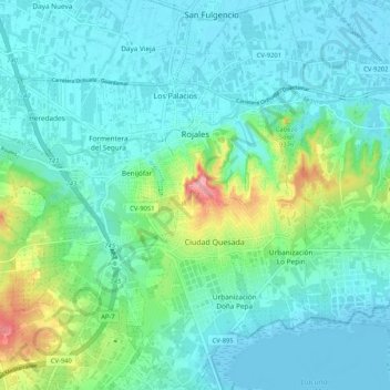
Name: Rojales topographic map, elevation, terrain.
Average elevation: 24 m
Minimum elevation: -6 m
Maximum elevation: 121 m
Make a donation
Gear up for your next adventure:
As an Amazon Associate, this site earns from qualifying purchases at no extra cost to you.
Other topographic maps
Click on a map to view its topography, its elevation and its terrain.
Canal de los Riegos de Levante
España > Comunidad Valenciana > La Vega Baja > Rojales > Urbanización Lo Pepin
Average elevation: 43 m
Make a donation
Gear up for your next adventure:
As an Amazon Associate, this site earns from qualifying purchases at no extra cost to you.
Make a donation
Gear up for your next adventure:
As an Amazon Associate, this site earns from qualifying purchases at no extra cost to you.