
Make a donation
Gear up for your next adventure:
As an Amazon Associate, this site earns from qualifying purchases at no extra cost to you.
Seebach topographic map
Click on the map to display elevation.
Make a donation
Gear up for your next adventure:
As an Amazon Associate, this site earns from qualifying purchases at no extra cost to you.
About this map
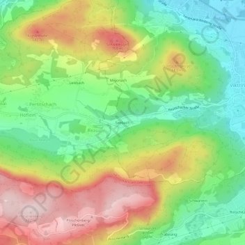
Name: Seebach topographic map, elevation, terrain.
Location: Seebach, Klagenfurt am Wörthersee, Kärnten, 9071, Österreich (46.56768 14.22201 46.60768 14.26201)
Average elevation: 593 m
Minimum elevation: 435 m
Maximum elevation: 799 m
Make a donation
Gear up for your next adventure:
As an Amazon Associate, this site earns from qualifying purchases at no extra cost to you.
Other topographic maps
Click on a map to view its topography, its elevation and its terrain.
St. Ruprecht
Österreich > Kärnten > Klagenfurt am Wörthersee
Bis zur Grundentlastung war der Müllneritsch Untertan des Bürgerspital-Dominiums. Der letzte Besitzer, der sich noch einen Obereigentümer gefallen lassen musste, war Josef Kuchkling. Im Grundbuch des Bürgerspitals hatte er die Urbar-Nr. 1. Er muss zur Jahrhundertmitte gestorben sein, denn die Realität…
Average elevation: 452 m